


UK National Data Repository
Answers to frequently asked questions

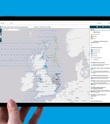
NSTA Open Data
We've put together some hints or tips on using the NSTA's Open Data based on queries we often receive.

Certain offshore UK continental shelf (UKCS) petroleum datasets, as well as onshore England petroleum data. These include, amongst others, GIS datasets, data packages supporting licence rounds, production data, well results and header information.
The NSTA does not publish onshore data for Scotland, Wales or Northern Ireland. No onshore infrastructure data is available for any location in the UK. Geothermal activity data is also not currently published by the NSTA.
The detail or granularity of the data provided is dependent on the dataset. Datasets can include information accessed through voluntary release by a company or disclosed via regulations under the Petroleum Act 1998 or Energy Act 2016.
You can see and filter the information behind the datasets to narrow down your search results or to make the query more specific. This is a useful way to apply filters without downloading an entire dataset.
- Search for the data
- Click on the data title
- Open ‘view data table’
- Select the Filter symbol
- Tick the box for the column you’d like to filter by. (Start typing if filter options don’t automatically populate).
- Go to the Download button
- Toggle on filter button
- Export into the desired format
The filters you apply to a dataset can be saved in case you need to view the data on a timely basis. For example, viewing current production data for certain operators or fields. This will save you time and effort in the future if you need to reapply the same filters.
See the above workflow on how to filter
- Copy the URL
- Save it as a shortcut on your desktop
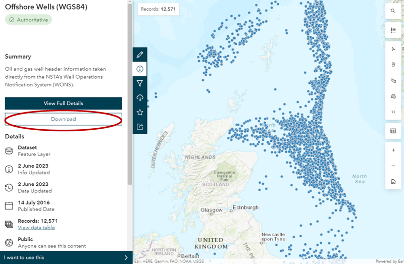
On your desired data, select the 'Download' button.
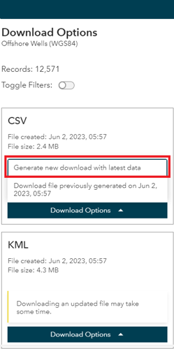
You will then be presented with the different formats you can download the data in, such as CSV, KML or Shapefile.
Many of our datasets update daily, so be sure to select 'Generate new download with latest data' for the best results.
A single web service that includes every available dataset is not available.
Web services must be added to web maps separately. However, you can download a zip file with all onshore or offshore shapefiles. You can also view many spatial datasets in one place on the online interactive maps for onshore and offshore oil and gas activity.
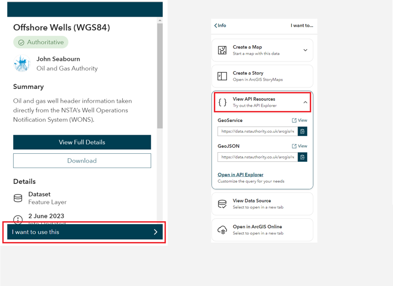
On your selected data, select the 'I want to use this' button.
Then, click 'View API Resources' and select the relevant URL.
There are multiple ways to connect to the data through web mapping services and APIs. These can be accessed within your own GIS software or directly in web maps and applications, removing the data management overhead. You should contact your software vendor if you are unsure on how to connect to services and APIs in your chosen software.
Web Maps
To use our data in your web maps, enter this URL into your web browser: https://data.nstauthority.co.uk/arcgis/rest/services. Find the service you need and add the chosen URL dataset, one at a time, to your web map.
Open Source APIs
You must search for the dataset you would like in the Open Data search bar. Once you have found a dataset, open it and go to ‘View Full Details’. This will bring up a page where you can find API Resources, under the ‘I want to…’ header. The data is provided in OGC WMS, GeoService or GeoJSON formats.
ESRI Software
If you use the ESRI suite of software, and would like to connect to our services within your own GIS software, please follow the below work flow.
- Open ArcCatalog
- Go to GIS servers
- 'Add ArcGIS Server'
- Enter the following URL:
For more ways to access our data see the page below.
You can work with API data in Excel by importing the data by following the methods highlighted by Microsoft.
The ArcGIS REST services are split into different folders by the coordinate reference system (WGS84, ED50, ETRS89 and BNG). They are separated again by content, for example: licences, wells and fields.
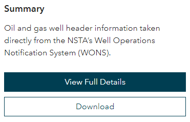
To learn more about the content in each service, read the summary information. This can be found via the Open Data main page. You must search for the data then select ‘view full details’.
To find the metadata, first click on the info icon on the blue bar at the left side of the screen.
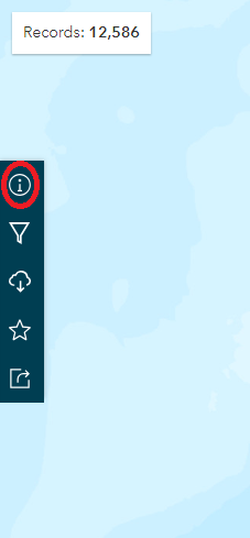
From there click on the "View Full Details", which takes to metadata, where you can see the summary of the content and the list of attributes with their types.
April 2023: Documentation for the PPRS, licenses and wells datasets has been published, use link below.
Aliases are also being added to attribute column names where possible. These are visible when you search for the data on the open data, click the dataset and then ‘view data table’. The aliases are also visible when using shapefiles or feature services in GIS software and opening the attribute table.
Subscriptions to data updates or changes are not available. The NSTAs datasets can occasionally change due to the addition of publishable information, among other reasons. A page has been created which highlights any changes we make to datasets, that may affect you. Please see the GIS Improvements and Changes page.
There are a number of PDF maps available to download on the printable maps page. Alternatively, make your own map using the ‘print’ widget button on the online interactive maps for onshore and offshore.
Copy the URL of the page you are on and send it to GIS@nstauthority.co.uk explaining the issue.
The search bar on Open Data only searches for our header datasets, not the data within them. For example, if you are looking for a specific licence, you must search for one of our licence datasets, and then filter the dataset information in the filter tab. You can filter with partial strings (contains some of the text characters). This helps when you don’t know the exact name or number for a licence/field/well.
Additionally, in the info tab, under number of records, it will say ‘view data table’ so you can see what the data is and what the columns are populated with.
When opening a CSV directly after downloading, sometimes Excel can mis-format the dates within the data.
We recommending opening a blank Excel document and following these guidelines to import a CSV and format the date column to ensure the data is read correctly.
Relinquishment reports are available to find and download using the link below. Please use the app to find the relevant blocks or licence number, and these should contain a URL link to the report. In addition, you can view which reports have been published within the last 6 months.
If you only require a list of the relinquishments, along with their report, please use this link to find this data. You can download the various versions (spreadsheet, shapefile, etc.) using the download button.
This depends on what you are looking for. For example, if you want to find a company who has relinquished a licence you would check the relinquishment reports app.
For a company production volume related query, filter by company on the PPRS spatial dashboard.
Company stakeholder (% equity) information can be found in the field partner dataset.
In order to filter the production data, users will need to use the exact reporting unit name. To find the correct names we have created a document containing a unique list of the reporting units.
The production page has information how to view and analyse the data.
There is a Power BI dashboard, which you can use to slice and dice the data as you so wish.
The GIS production app allows you to filter an download the data.
We do not actively publish the wells symbology layer, however you can download a copy of the ESRI LYR file.
The well codes for the primary target attribute are operator specific. If you would like to know more information, please contact the operator.
NSTA virtual map gallery tour
Take a look at some of our most popular and newest maps; and get some hint and tips on how to use them.